
Exploring the Role of RTK GPS in Drone Technology
The drone industry has experienced explosive growth in recent years, with applications ranging from agriculture and construction to surveying and filmmaking. One of the most significant advancements enhancing the precision and reliability of drones is rtk gps (Real-Time Kinematic Global Positioning System). In this article, we’ll be exploring the role of RTK GPS in drone technology, its benefits, and how it is revolutionizing aerial data collection.
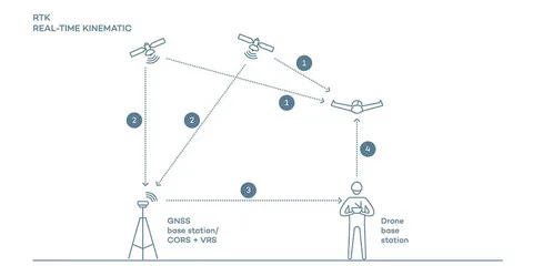
What is RTK GPS?
RTK GPS is a satellite navigation technique that improves the accuracy of position data derived from satellite-based positioning systems. Unlike standard GPS, which can have errors ranging from a few meters, RTK GPS provides centimeter-level accuracy. This is achieved by using a fixed base station and a rover (the drone), allowing for real-time corrections and significantly enhanced positioning precision.
Why Accuracy Matters in Drone Applications
In many drone operations, accuracy isn’t just a luxury—it’s a necessity. Whether mapping a construction site or creating 3D models of terrain, even small positional errors can result in costly mistakes. This is where RTK GPS in drone technology becomes essential.
Drones equipped with RTK systems are capable of:
- High-precision mapping
- Accurate repeatable flight paths
- Better geotagging of images and videos
- Reduced need for ground control points (GCPs)
Benefits of Using RTK GPS in Drone Technology
Let’s delve deeper into the specific advantages:
1. Enhanced Surveying and Mapping
RTK-enabled drones allow surveyors to collect accurate data more quickly than traditional methods. This drastically reduces fieldwork time and post-processing efforts.
2. Improved Workflow Efficiency
Thanks to the precise positioning capabilities, there’s less need for manual measurements or rework. This results in increased productivity and cost savings.
3. Better Data Integrity
When exploring the role of RTK GPS in drone technology, one cannot ignore the improvement in data consistency. Images and point clouds generated by RTK drones are more reliable, making them suitable for high-stakes industries like mining and infrastructure.
Industries Benefiting from RTK GPS Integration
Several sectors have adopted RTK technology in their drone operations:
- Agriculture: Precision farming benefits from accurate field mapping and crop monitoring.
- Construction: Site planning, volume measurements, and progress tracking are made easier.
- Utilities: Inspection of power lines, pipelines, and other assets is more precise.
- Environmental Monitoring: Accurate geographic data collection supports better analysis and conservation efforts.
Conclusion
As drone technology continues to evolve, the integration of advanced navigation systems like RTK GPS is becoming increasingly vital. By exploring the role of RTK GPS in drone technology, we see its potential to transform aerial data collection across industries. Its ability to deliver real-time, centimeter-level positioning enables drones to operate more efficiently, safely, and accurately—paving the way for smarter, more informed decisions.